FavouritesSign inCreate accountAdd my village

The guide to Spain's villages, one municipality at a time.

Your village is waiting for you.

@8000pueblos

Explore

  • Villages
  • Create my route
  • Experiences

Practical guide

  • Guides
  • About us
  • How it works
  • Village comparison
  • Map of Spain
  • Opportunities
  • Living in a village

Join us

  • Create your account
  • For town councils
  • For professionals
  • Contact

© 2026 8000pueblos.com

Some links are affiliate links: if you book, we receive a commission at no cost to you.

SupportPrivacyTermsCookiesLegal notice
en
  • Español
  • English
  • Français
  • Português
  • Italiano
Sign inCreate account
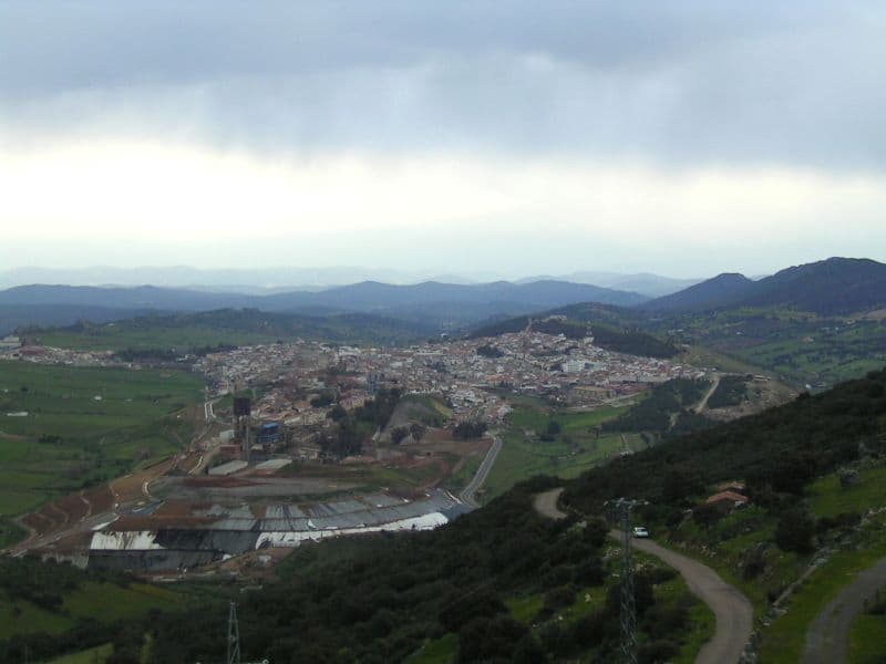
View of Almadénamata_es · CC BY 2.0

Almadén

Village

Almadén is a town and municipality in the Spanish province of Ciudad Real, within the autonomous community of Castile-La Mancha. The town is located at 4° 49' W and 38° 46' N and is 589 meters (1,932 ft) above sea level. Almadén is in the Sierra Morena. The name Almadén is from the Arabic: المعدن, romanized: al-maʻdin, lit. 'the metal', 'the mineral' or 'lode', and so by extension, the place where these are excavated, 'the mine'. Originally a Roman, and later, a Moorish mining settlement when taken from the Visigoths, the town was captured by the Christians in 1151 under king Alfonso VII and given to the Knights of the Order of Calatrava.

Read moreRead less

The mercury deposits of Almadén account for the largest quantity of liquid mercury metal produced in the world. Approximately 250,000 metric tons (280,000 short tons) of mercury have been produced there in the past 2000 years. Due to the toxicity of mercury and its byproducts to humans, the mine has variously employed penal labour, slave labour, and prisoners of war over its long history. Almadén mine stopped working in 2002, due to the European mercury mining prohibition. In 2006, the mine opened to the public who can visit the first level, 50 metres (160 ft) underground.

In 2012, Almadén and Idrija (Slovenia) were declared World Heritage Sites, with the nomination "Heritage of Mercury".

Text from Wikipedia (CC BY-SA)

Village information

Coat of arms of Almadén
Province
Ciudad Real
Autonomous community
Castilla-La Mancha
Population (INE 2025)
4,855
Altitude
576 m
Area (IGN)
239 km²
Postcode
13400
Demonym
Almadenenses
View on the map
  • Overview
  • See and do
  • Events
  • Stay
  • Eat
  • Live here
  • Opportunities
  • Practical info
  • Gallery

What to see

  1. 1Horno de aludeles de Almadén
  2. 2Plaza de toros de Almadén
  3. 3Real Hospital de Mineros de San Rafael
  4. 4Minas de Almadén
  5. 5Castillo de Retamar
  6. 6Museo del Mercurio
Data from Wikidata and OpenStreetMapSee more

What to do

  1. 1Hiking: Camino de los Mineros - Etapa 1
  2. 2Street market
Data from OpenStreetMapSee more
  • 2 places to stayIllustrative photo · Valdavia · CC BY-SA 3.0

    Accommodation

    2 places to stay in Almadén

    See places to stay
  • 7 restaurantsIllustrative photo · Grey World · CC BY 2.0

    Eat

    7 restaurants in Almadén

    See where to eat
  • 2 experiencesIllustrative photo · Rocco Rossi · CC BY 2.0

    Experiences

    2 experiences in Almadén

    See experiences

Useful information

Everything you need for your visit or your day-to-day

Tap a row to see it on the map and how far away it is.

Town council

    • Phone: 926 71 00 52
    • Official website: www.almaden.es
    • Email: intervencion@ayto-almaden.com
  • Tourist office: Oficina de Turismo de la Comarca de AlmadenWaldo Ferrer, S/N · 13400
    • Phone: 926 71 04 38
    • Email: turismo@almaden.es

Services and transport

Education, sport and elderly care

Connectivity

  • Fibre broadband· of homes100 %
  • 4G mobile coverage· of homes100 %
  • 5G coverage· of homes100 %

No data on: train station, EV chargers, street market, pool, care home.

Data from OpenStreetMap (ODbL), extract from October 2026: we count what is mapped within the municipal boundary. "No data" means OpenStreetMap doesn't have it, not that it doesn't exist. Completed with Overture Maps (CDLA-Permissive-2.0): the pharmacies, health centres, petrol stations, banks, cash machines, food shops and schools that OpenStreetMap was missing. Town hall contact details: General Database of Local Entities (Spanish Ministry of Finance); tourist offices: each region's open registry, where it publishes one. Connectivity: Spanish Ministry for Digital Transformation, % of homes covered in June 2025.

Almadén Town Hall

Municipal information, services, procedures and grants.

Go to municipal information

Keep exploring

More villages near Almadén

Surprise me
SimonWaldherr · CC BY-SA 4.0ChillónCiudad Real · 3.4 km away
19Tarrestnom65 · CC BY-SA 4.0AlamilloCiudad Real · 12 km away
19Tarrestnom65 · CC BY-SA 4.0AlmadenejosCiudad Real · 12 km away
Camome74 · CC BY-SA 3.0GuadalmezCiudad Real · 13 km away

Where to sleep in Almadén

2 registered places to stay

See places to stay
Back to homeNextSee and do