 Lucas Martínez Farra… · CC BY-SA 3.0
Coastal village
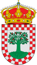
A Caniza is a municipality in Galicia, Spain, in the province of Pontevedra. A Caniza is part of the comarca of A Paradanta. It has an area of 108.1 km2 and a population approaching 5,200 inhabitants in 2018 distributed across 9 parishes.
This category of village municipality, known for its excellent tourism and the strong momentum that is experiencing the industrial and business sector.
The local cuisine, including meat products, most notably ham, is central in many important events, such as the long-standing pilgrimages to A Franqueira, as declared by the Autonomous Community of Galicia Tourist Interest Party, or the known Ham Fair, being examples.
This mid-mountain location and interior provides the opportunity to see a marked diversity caused by the uneven landscape of mountains and valleys and to know its artistic heritage, the customs of the people and enjoy the many popular events that take place throughout the year. The tourist offer is complete with services designed to improve the quality of life of its inhabitants and, at the same time, to meet the needs and demands of travelers who daily visit to Caniza.
Text from Wikipedia (CC BY-SA)
Keep exploring
10 places to explore A Cañiza at your own pace. Each number matches its point on the map.

Tell me how much time you have and what you like, and I'll put the places in A Cañiza in order so you don't go back and forth.
Tap “+ Add to my route” on the places you want to see. We'll split what you can do on foot from what's better by car.
La iglesia de Santa María es un templo católico de la parroquia española de Franqueira.
Iglesia

La iglesia de Santa Teresa es un templo católico de la parroquia española de La Cañiza.
Iglesia

Museo
Iglesia
Iglesia
Iglesia
Iglesia
Iglesia
Iglesia
Iglesia
Monuments from Wikidata; summaries from Wikipedia (CC BY-SA) and photos from Wikimedia Commons, credited to their authors.
5 plans to experience A Cañiza on the move, not just passing through.
2 activities
1 activity
2 activities
Places and plans from OpenStreetMap (ODbL): what is mapped within the municipal boundary, by name. If something is missing, it can be added there and will appear here in the next update.
What there really is in the village and around it, with distances. If an activity isn't on this list, we haven't found it nearby.

