FavouritesSign inCreate accountAdd my village

The guide to Spain's villages, one municipality at a time.

Your village is waiting for you.

@8000pueblos

Explore

  • Villages
  • Create my route
  • Experiences

Practical guide

  • Guides
  • About us
  • How it works
  • Village comparison
  • Map of Spain
  • Opportunities
  • Living in a village

Join us

  • Create your account
  • For town councils
  • For professionals
  • Contact

© 2026 8000pueblos.com

Some links are affiliate links: if you book, we receive a commission at no cost to you.

SupportPrivacyTermsCookiesLegal notice
en
  • Español
  • English
  • Français
  • Português
  • Italiano
Sign inCreate account
View of Siete AguasMillars · CC BY-SA 3.0

Siete Aguas

Village

Siete Aguas is a municipality in the comarca of Hoya de Buñol in the Valencian Community, Spain.

Text from Wikipedia (CC BY-SA)

Village information

Coat of arms of Siete Aguas
Province
Valencia
Population (INE 2025)
1,289
Altitude
707 m
Area (IGN)
111 km²
District
Hoya de Buñol
Postcode
46392
View on the map
  • Overview
  • See and do
  • Events
  • Stay
  • Eat
  • Live here
  • Opportunities
  • Practical info
  • Gallery

Keep exploring

More villages near Siete Aguas

Surprise me
Enrique Íñiguez Rodríguez (Qoan) · CC BY-SA 3.0BuñolValencia · 12 km away
B25es · CC BY-SA 3.0YátovaValencia · 13 km away
19Tarrestnom65 · CC BY-SA 4.0CheraValencia · 14 km away
19Tarrestnom65 · CC BY-SA 3.0MacastreValencia · 15 km away

Where to sleep in Siete Aguas

4 registered places to stay

See places to stay
PreviousOverviewBack to homeNextEvents

What to see

14 places to explore Siete Aguas at your own pace. Each number matches its point on the map.

Ask Poblete for a route

Tell me how much time you have and what you like, and I'll put the places in Siete Aguas in order so you don't go back and forth.

How much time do you have?
How are you getting around?
What do you like? (you can pick several)

Only with places listed for Siete Aguas.

My route around Siete Aguas

Tap “+ Add to my route” on the places you want to see. We'll split what you can do on foot from what's better by car.

Places you can add

  1. 1

    1.

    Fuente de agua potableBien inmueble de Etnología
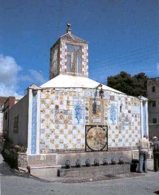
    Fuente de los Siete Caños
    Wikimedia Commons · CC BY-SA 3.0
  2. 2

    2.

    IglesiaBien de Relevancia Local

    Iglesia de San Juan Bautista
    Wikimedia Commons · CC BY-SA 2.5
  3. 3

    3.

    Retablo cerámico, del siglo XX.

    Retablo cerámicoBien de Relevancia Local

    Retablo cerámico de San Isidro Labrador
    Wikimedia Commons · CC BY-SA 3.0
  4. 4

    4.

    La torre del Mojón o torre de la Contienda es un bien de interés cultural formado por los restos de una torre de vigía o de defensa situada en la frontera entre Castilla y el Reino de Valencia.

    TorreBien de interés cultural

  5. 5

    5.

    Cementerio, del siglo XX.

    CementerioBien inmueble de Etnología

  6. 6

    6.

    Pozo, del siglo XX.

    PozoBien inmueble de Etnología

  7. 7

    7.

    Puente carretero, del siglo XVIII.

    Puente carreteroBien de Relevancia Local

  8. 8

    8.

    El Museo Municipal de Siete Aguas (Provincia de Valencia, España) cuenta con material paleontológico procedente del término municipal, y se presenta al público acompañado de documentación gráfica sobre su situación cronológica y estratigráfica, primando en todo caso la información local sobre la…

    Museo

  9. 9

    9.

    Monumento

  10. 10

    10.

    Cumbre

  11. 11

    11.

    Cumbre

  12. 12

    12.

    Cumbre

  13. 13

    13.

    Cumbre

  14. 14

    14.

    Cumbre

Monuments from Wikidata; summaries from Wikipedia (CC BY-SA) and photos from Wikimedia Commons, credited to their authors.

What to do

4 plans to experience Siete Aguas on the move, not just passing through.

Hiking

3 activities

Hiking: Camino de Santiago de la Lana de Valencia

Hiking: GR 7 · Comunidad Valenciana. Fredes - el Pinós

Hiking: Camí Natural Turia - Cabriel

More routes on WikilocHiking routes on Google Maps

Natural areas

1 activity

Paraje Natural Municipal Sierra de Chiva

Getting there

Places and plans from OpenStreetMap (ODbL): what is mapped within the municipal boundary, by name. If something is missing, it can be added there and will appear here in the next update.

In and around Siete Aguas

What there really is in the village and around it, with distances. If an activity isn't on this list, we haven't found it nearby.

  • WineriesBodega One 24K · 9 km away, in Requena · 4 within 15 kmGetting there
  • ClimbingBuñol - Sector Los Puentes - Puente Natural · 11.4 km away, in Buñol · 15 within 20 kmGetting there
  • Reservoirs and lakesEmbalse de Buseo · 12.2 km away, in Chera · 2 within 15 kmGetting there
  • Horse ridingPicadero municipal de Yátova. Parque de San Vicente · 12.9 km away, in YátovaGetting there
  • Via ferratasUnnamed on the map · 21 km away, in ChulillaGetting there