FavouritesSign inCreate accountAdd my village

The guide to Spain's villages, one municipality at a time.

Your village is waiting for you.

@8000pueblos

Explore

  • Villages
  • Create my route
  • Experiences

Practical guide

  • Guides
  • About us
  • How it works
  • Village comparison
  • Map of Spain
  • Opportunities
  • Living in a village

Join us

  • Create your account
  • For town councils
  • For professionals
  • Contact

© 2026 8000pueblos.com

Some links are affiliate links: if you book, we receive a commission at no cost to you.

SupportPrivacyTermsCookiesLegal notice
en
  • Español
  • English
  • Français
  • Português
  • Italiano
Sign inCreate account
View of El ToroJuan Emilio Prades Bel · CC BY 4.0

El Toro

Village

El Toro is a municipality in the comarca of Alto Palancia, Castellón, Valencia, Spain.

Read moreRead less

The Sierra del Toro mountain range is named after this town.

Text from Wikipedia (CC BY-SA)

Village information

Coat of arms of El Toro
Province
Castellón
Autonomous community
Valencia
Population (INE 2025)
256
Altitude
32 m
Area (IGN)
109 km²
District
Alto Palancia
Postcode
12429
View on the map
  • Overview
  • See and do
  • Events
  • Stay
  • Eat
  • Live here
  • Opportunities
  • Practical info
  • Gallery

Keep exploring

More villages near El Toro

Surprise me
Coentor · CC BY-SA 3.0BarracasCastellón · 5.8 km away
Juan Emilio Prades Bel · CC BY 4.0TorásCastellón · 8.7 km away
rodrigum · CC BY 4.0BejísCastellón · 8.8 km away
Wakamai · CC BY-SA 3.0Pina de MontalgraoCastellón · 9 km away

Where to sleep in El Toro

1 registered place to stay

See places to stay
PreviousOverviewBack to homeNextEvents

What to see

21 places to explore El Toro at your own pace. Each number matches its point on the map.

Ask Poblete for a route

Tell me how much time you have and what you like, and I'll put the places in El Toro in order so you don't go back and forth.

How much time do you have?
How are you getting around?
What do you like? (you can pick several)

Only with places listed for El Toro.

My route around El Toro

Tap “+ Add to my route” on the places you want to see. We'll split what you can do on foot from what's better by car.

Places you can add

  1. 1

    1.

    El castillo de El Toro (Provincia de Castellón, España) se sitúa en la parte superior del núcleo urbano de la población en el paraje denominado "El Cerrito" (1.040 m).

    CastilloBien de interés cultural

    Castillo de El Toro
    Wikimedia Commons · CC BY-SA 3.0
  2. 2

    2.

    La casa consistorial de El Toro, en la provincia de Castellón es una construcción civil de finales de la Edad Media y principios del Renacimiento que aúna la representación y funciones de los nuevos poderes civiles, la casa de la villa o ayuntamiento, junto a un espacio, la lonja, destinado a…

    Casa consistorialBien de interés cultural

    Casa consistorial de El Toro
    Wikimedia Commons · CC BY-SA 3.0
  3. 3

    3.

    La ermita de San Roque en el término municipal de El Toro, comarca del Alto Palancia (Provincia de Castellón, España), es una ermita erigida, entre los siglos XIV y XVII, en honor de San Roque,se localiza al pie de la carretera que se dirige al Peña Salada en la conocida como Hoya de San Roque…

    EremitorioBien de Relevancia Local
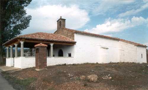
    Ermita de San Roque
    Wikimedia Commons · CC BY-SA 3.0
  4. 4

    4.

    La iglesia de Nuestra Señora de los Ángeles de El Toro (Provincia de Castellón, España) está situada en la Plaza de la Iglesia y fue construida en el primer tercio del siglo XVII

    Iglesia parroquial católicaBien de Relevancia Local

    Iglesia de Nuestra Señora de los Ángeles
    Wikimedia Commons · CC BY-SA 3.0
  5. 5

    5.

    El aeródromo de El Toro (Castellón) fue una instalación utilizada durante la Guerra Civil Española por la Fuerza Aérea de la República Española.

    AeródromoBien de Relevancia Local

    Aeródromo de El Toro
    19Tarrestnom65 · CC BY-SA 4.0
  6. 6

    6.

    Fuente de agua potable, del siglo XVIII.

    Fuente de agua potableBien inmueble de Etnología

    Fuente de Jariz
    Pacopac · CC BY-SA 4.0
  7. 7

    7.

    AldeaBien de Relevancia Local

  8. 8

    8.

    Fuente de agua potableBien inmueble de Etnología

  9. 9

    9.

    AbrevaderoBien inmueble de Etnología

  10. 10

    10.

    LavaderoBien inmueble de Etnología

  11. 11

    11.

    Molino hidráulicoBien inmueble de Etnología

  12. 12

    12.

    Pozo de nieveBien de Relevancia Local

  13. 13

    13.

    Conjunto monumentalBien inmueble de Etnología

  14. 14

    14.

    Cumbre

  15. 15

    15.

    Cumbre

  16. 16

    16.

    Cumbre

  17. 17

    17.

    Cumbre

  18. 18

    18.

    Cumbre

  19. 19

    19.

    Cumbre

  20. 20

    20.

    Cumbre

  21. 21

    21.

    Ruinas

Monuments from Wikidata; summaries from Wikipedia (CC BY-SA) and photos from Wikimedia Commons, credited to their authors.

What to do

2 plans to experience El Toro on the move, not just passing through.

Bike

2 activities

MTB: Nacimiento del Palancia

MTB: Sierra del Toro

Cycling routes on Google Maps

Places and plans from OpenStreetMap (ODbL): what is mapped within the municipal boundary, by name. If something is missing, it can be added there and will appear here in the next update.

More walks near El Toro

Routes shared by hikers and waymarked trails, with their map and elevation profile.

See routes on WikilocHiking routes on Google Maps

In and around El Toro

What there really is in the village and around it, with distances. If an activity isn't on this list, we haven't found it nearby.

  • WineriesBodegas Domeco de Jarauta · 9 km away, in Bejís · 2 within 15 kmGetting there
  • ClimbingVía Ferrata La Mulatica · 14.4 km away, in Andilla · 23 within 20 kmGetting there
  • Via ferratasVía Ferrata La Mulatica · 14.4 km away, in AndillaGetting there
  • Spas and hot springsFuente de Los Baños · 21 km away, in MontanejosGetting there
  • Skiing and snowEstación esquí Javalambre · 27 km away, in Camarena de la SierraGetting there