FavouritesSign inCreate accountAdd my village

The guide to Spain's villages, one municipality at a time.

Your village is waiting for you.

@8000pueblos

Explore

  • Villages
  • Create my route
  • Experiences

Practical guide

  • Guides
  • About us
  • How it works
  • Village comparison
  • Map of Spain
  • Opportunities
  • Living in a village

Join us

  • Create your account
  • For town councils
  • For professionals
  • Contact

© 2026 8000pueblos.com

Some links are affiliate links: if you book, we receive a commission at no cost to you.

SupportPrivacyTermsCookiesLegal notice
en
  • Español
  • English
  • Français
  • Português
  • Italiano
Sign inCreate account
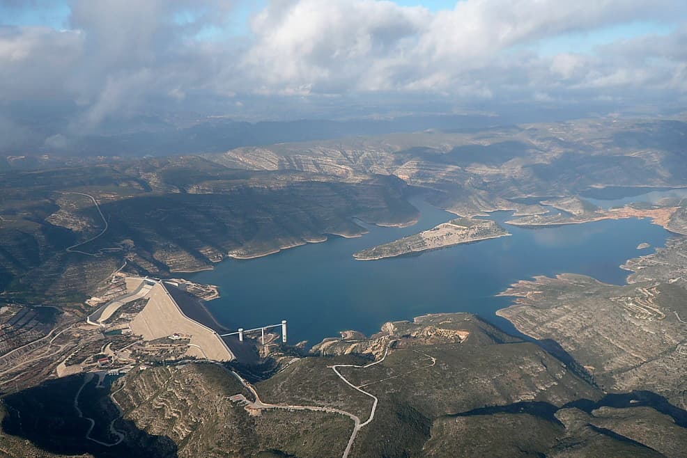
View of TousJavigar · CC BY-SA 4.0

Tous

Mountain village

Tous is a municipality in the Valencian Community, in the province of Valencia. The town is notable for the dam failure which occurred on 20 October 1982, when an unusually severe rainfall swelled the river Jucar, breaking the Tous Dam. The dam operator was unable to open the spillway gate, and the water overtopped the dam, which then failed, provoking a flood of 16,000 m3/s and more than 30 casualties. The flood was called La Pantanada.

Text from Wikipedia (CC BY-SA)

Village information

Coat of arms of Tous
Province
Valencia
Population (INE 2025)
1,354
Altitude
100,126 m
Area (IGN)
130 km²
District
Ribera Alta
Postcode
46269
View on the map
  • Overview
  • See and do
  • Events
  • Stay
  • Eat
  • Live here
  • Opportunities
  • Practical info
  • Gallery

Keep exploring

More villages near Tous

Surprise me
Plamagado~commonswiki · Public domainMasalavésValencia · 5.7 km away
Enrique Íñiguez Rodríguez (Qoan) · CC BY-SA 3.0GavardaValencia · 5.7 km away
Joan Garcia Garcia · CC BY-SA 4.0SumacàrcerValencia · 5.9 km away
CRESPO-AZORIN · Public domainAlbericValencia · 6.4 km away

Where to sleep in Tous

2 registered places to stay

See places to stay
PreviousOverviewBack to homeNextEvents

What to see

12 places to explore Tous at your own pace. Each number matches its point on the map.

Ask Poblete for a route

Tell me how much time you have and what you like, and I'll put the places in Tous in order so you don't go back and forth.

How much time do you have?
How are you getting around?
What do you like? (you can pick several)

Only with places listed for Tous.

My route around Tous

Tap “+ Add to my route” on the places you want to see. We'll split what you can do on foot from what's better by car.

Places you can add

  1. 1

    1.

    El Castillo de Tous era una edificación defensiva medieval. Se encuentra en el municipio de Tous (Valencia), en un cerro cuya cumbre sobresale de las aguas del pantano.

    CastilloBien de interés cultural

    Castillo de Tous
    Vicenç Salvador Torres Guerola · CC BY-SA 3.0
  2. 2

    2.

    La Torre de vigilancia de Tous es un bien de interés cultural que se encuentra en el término municipal de Tous (Valencia). Su código es 46.20.246-003 y su inscripción se debe a una declaración genérica que afecta a todas las edificaciones de su tipo.

    Torre de vigilanciaBien de interés cultural

    Torre de vigilancia de Tous
    Carolina Latorre Canet · CC BY-SA 3.0
  3. 3

    3.

    La iglesia parroquial de San Miguel Arcángel es un templo católico situado en la plaza de la Iglesia, 1, en el municipio de Tous. Es Bien de Relevancia Local con identificador número 46.12.246-001.

    IglesiaBien de Relevancia Local

    Iglesia de San Miguel Arcángel
    B25es · CC BY-SA 3.0
  4. 4

    4.

    Cueva

  5. 5

    5.

    Cueva

  6. 6

    6.

    Cueva

  7. 7

    7.

    Mirador

  8. 8

    8.

    Mirador

  9. 9

    9.

    Mirador

  10. 10

    10.

    Cueva

  11. 11

    11.

    Cueva

  12. 12

    12.

    Cueva

Monuments from Wikidata; summaries from Wikipedia (CC BY-SA) and photos from Wikimedia Commons, credited to their authors.

What to do

3 plans to experience Tous on the move, not just passing through.

Hiking

1 activity

Hiking: PR-CV 263 · Sendero Pollet - Terrabona

More routes on WikilocHiking routes on Google Maps

Bike

2 activities

Cycling route: Camí de la Taronja

Cycling route: PR-CV 413 · Cicloruta del Campillo hasta la Garrofera

Cycling routes on Google Maps

Places and plans from OpenStreetMap (ODbL): what is mapped within the municipal boundary, by name. If something is missing, it can be added there and will appear here in the next update.

In and around Tous

What there really is in the village and around it, with distances. If an activity isn't on this list, we haven't found it nearby.

  • Reservoirs and lakesEmbalse de Tous · in the village · 2 within 15 kmGetting there
  • Via ferratasEl Chorrico · in the village · 3 within 25 kmGetting there
  • Horse ridingCentro Hípico Hermanos Monzó · 6.9 km away, in BenimodoGetting there