FavouritesSign inCreate accountAdd my village

The guide to Spain's villages, one municipality at a time.

Your village is waiting for you.

@8000pueblos

Explore

  • Villages
  • Create my route
  • Experiences

Practical guide

  • Guides
  • About us
  • How it works
  • Village comparison
  • Map of Spain
  • Opportunities
  • Living in a village

Join us

  • Create your account
  • For town councils
  • For professionals
  • Contact

© 2026 8000pueblos.com

Some links are affiliate links: if you book, we receive a commission at no cost to you.

SupportPrivacyTermsCookiesLegal notice
en
  • Español
  • English
  • Français
  • Português
  • Italiano
Sign inCreate account
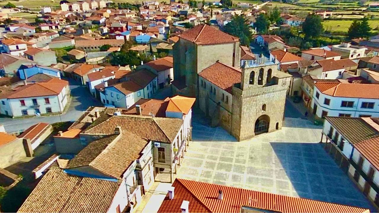
View of Villavieja de YeltesMscalderero · CC BY-SA 4.0

Villavieja de Yeltes

Village

Villavieja de Yeltes is a municipality in Salamanca, Castile and León, Spain.

Text from Wikipedia (CC BY-SA)

Village information

Province
Salamanca
Autonomous community
Castilla y León
Population (INE 2025)
676
Altitude
742 m
Area (IGN)
51.8 km²
Postcode
37260
Demonym
villaviejense
View on the map
  • Overview
  • See and do
  • Events
  • Stay
  • Eat
  • Live here
  • Opportunities
  • Practical info
  • Gallery

What to see

  1. 1Iglesa San Pedro Advíncula
  2. 2Dolmen a la Libertad
  3. 3Ermita de Nuestra Señora de los Caballeros
  4. 4Obelisco a la Libertad
  5. 5Arco de una antigua ermita
Data from OpenStreetMapSee more

Photo gallery

See all photos
  • Mscs · CC BY-SA 4.0
  • Adolfo Andrés · CC BY-SA 3.0
  • Adolfo Andrés · CC BY-SA 3.0
  • Mscs · CC BY-SA 4.0
  • 3 places to stayIllustrative photo · Valdavia · CC BY-SA 3.0

    Accommodation

    3 places to stay in Villavieja de Yeltes

    See places to stay
  • Illustrative photo · Grey World · CC BY 2.0

    Eat

    None in the village; the nearest is 15.1 km away

    See where to eat
  • Illustrative photo · Àngela Llop · CC BY-SA 4.0

    Experiences

    No experiences listed yet; 2 kinds of activity within 30 km

    See experiences

Useful information

Everything you need for your visit or your day-to-day

Tap a row to see it on the map and how far away it is.

Town council

    • Official website: www.villaviejadeyeltes.es
    • Email: villaviejayel@retemail.es

Services and transport

Travelling with your pet

Parks, beaches and places to stay that OpenStreetMap marks as dog-friendly. Many places allow dogs without it being marked: ask when you book.

Education, sport and elderly care

Connectivity

  • Fibre broadband· of homes97 %
  • 4G mobile coverage· of homes100 %
  • 5G coverage· of homes100 %

No data on: tourist office, train station, transport, ATMs, supermarkets, post office, EV chargers, motorhomes, car parks, street market, nursery school, secondary school.

Data from OpenStreetMap (ODbL), extract from October 2026: we count what is mapped within the municipal boundary. "No data" means OpenStreetMap doesn't have it, not that it doesn't exist. Completed with Overture Maps (CDLA-Permissive-2.0): the pharmacies, health centres, petrol stations, banks, cash machines, food shops and schools that OpenStreetMap was missing. Town hall contact details: General Database of Local Entities (Spanish Ministry of Finance); tourist offices: each region's open registry, where it publishes one. Connectivity: Spanish Ministry for Digital Transformation, % of homes covered in June 2025.

Villavieja de Yeltes Town Hall

Municipal information, services, procedures and grants.

Go to municipal information

Keep exploring

More villages near Villavieja de Yeltes

Surprise me
Mscs · CC BY-SA 4.0Villares de YeltesSalamanca · 4.7 km away
Mscs · CC BY-SA 4.0BogajoSalamanca · 6.3 km away
Gelomadrid15 · CC BY-SA 4.0FuentelianteSalamanca · 8.9 km away
GFreihalter · CC BY-SA 3.0Yecla de YeltesSalamanca · 9.5 km away

Where to sleep in Villavieja de Yeltes

3 registered places to stay

See places to stay
Back to homeNextSee and do