FavouritesSign inCreate accountAdd my village

The guide to Spain's villages, one municipality at a time.

Your village is waiting for you.

@8000pueblos

Explore

  • Villages
  • Create my route
  • Experiences

Practical guide

  • Guides
  • About us
  • How it works
  • Village comparison
  • Map of Spain
  • Opportunities
  • Living in a village

Join us

  • Create your account
  • For town councils
  • For professionals
  • Contact

© 2026 8000pueblos.com

Some links are affiliate links: if you book, we receive a commission at no cost to you.

SupportPrivacyTermsCookiesLegal notice
en
  • Español
  • English
  • Français
  • Português
  • Italiano
Sign inCreate account
View of XeracoAvecendrell · CC BY-SA 3.0

Xeraco

Coastal town

Xeraco (Valencian:; Spanish: Jaraco) is a municipality in the comarca of Safor in Valencia, Spain. Like many coastal towns it is divided into the original village of Xeraco and the new beach resort, Xeraco Platja. Xeraco is separated from the neighbouring beach resorts of Gandia and Tavernes by the Riu Vaca and swamp land containing native population of birds. It is an essentially agricultural village.

Text from Wikipedia (CC BY-SA)

Village information

Coat of arms of Xeraco
Province
Valencia
Population (INE 2025)
6,149
Altitude
13 m
Area (IGN)
20.7 km²
District
Safor
Postcode
46770
View on the map
  • Overview
  • See and do
  • Events
  • Stay
  • Eat
  • Live here
  • Opportunities
  • Practical info
  • Gallery

Keep exploring

More villages near Xeraco

Surprise me
19Tarrestnom65 · CC BY-SA 4.0XeresaValencia · 2.7 km away
Joanbanjo · CC BY-SA 3.0Tavernes de la ValldignaValencia · 6.2 km away
Isidrepege · CC BY-SA 3.0BarxValencia · 7.7 km away
Vicenç Salvador Torres Guerola · CC BY-SA 3.0Benifairó de la ValldignaValencia · 7.8 km away
PreviousOverviewBack to homeNextEvents

What to see

14 places to explore Xeraco at your own pace. Each number matches its point on the map.

Ask Poblete for a route

Tell me how much time you have and what you like, and I'll put the places in Xeraco in order so you don't go back and forth.

How much time do you have?
How are you getting around?
What do you like? (you can pick several)

Only with places listed for Xeraco.

My route around Xeraco

Tap “+ Add to my route” on the places you want to see. We'll split what you can do on foot from what's better by car.

Places you can add

  1. 1

    1.

    La torre de vigilancia de Jaraco, se encuentra a unos 2 km en línea recta de la playa y aproximadamente a 400 metros de la actual carretera comarcal Nazaret-Oliva o antiguo Camino Real de Madrid a Valencia; en el margen derecho del río Vaca o Jaraco, en un paraje conocido como el Gorg.

    Torre de vigilancia costeraBien de interés cultural
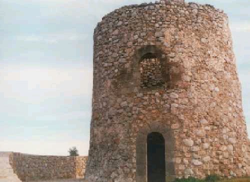
    Torre de vigilancia de Xeraco
    Wikimedia Commons · CC BY-SA 3.0
  2. 2

    2.

    IglesiaBien de Relevancia Local

    Iglesia de Nuestra Señora de la Encarnación
    Wikimedia Commons · CC BY-SA 3.0
  3. 3

    3.

    ErmitaBien de Relevancia Local

  4. 4

    4.

    Retablo cerámicoBien inmueble de Etnología

  5. 5

    5.

    Retablo cerámico, del siglo XX.

    Retablo cerámicoBien inmueble de Etnología

  6. 6

    6.

    Iglesia

  7. 7

    7.

    Cueva

  8. 8

    8.

    Mirador

  9. 9

    9.

    Cueva

  10. 10

    10.

    Cueva

  11. 11

    11.

    Mirador

  12. 12

    12.

    Mirador

  13. 13

    13.

    Cueva

  14. 14

    14.

    Mirador

Monuments from Wikidata; summaries from Wikipedia (CC BY-SA) and photos from Wikimedia Commons, credited to their authors.

What to do

6 plans to experience Xeraco on the move, not just passing through.

Hiking

3 activities

Hiking: El Camí IT5TR5 El Camí del Sud: de Dénia a Castelló de la Plana

Hiking: Ruta 1 oficial de Senderisme de Xeraco

Hiking: Ruta 2 oficial de Senderisme de Xeraco

More routes on WikilocHiking routes on Google Maps

Water

1 activity

Platja de Xeraco

Getting there

Street market

1 activity

Street market (Saturdays)

Getting there

Bike

1 activity

Cycling route: EV8

Cycling routes on Google Maps

Places and plans from OpenStreetMap (ODbL): what is mapped within the municipal boundary, by name. If something is missing, it can be added there and will appear here in the next update.

In and around Xeraco

What there really is in the village and around it, with distances. If an activity isn't on this list, we haven't found it nearby.

  • BeachesPlatja de Xeraco · in the village · 16 within 15 kmGetting there
  • Horse ridingCentro Hípico Los Robles · 4.9 km away, in GandiaGetting there
  • ClimbingGandía - sector topdeckio · 5.2 km away, in Gandia · 4 within 20 kmGetting there
  • Sailing and water sportsPuerto Deportivo de Gandia · 6.5 km away · 3 within 20 kmGetting there
  • GolfGolf de Gandia · 6.6 km away, in Gandia · 3 within 20 kmGetting there
  • WineriesEls Coveros · 14.7 km away, in OlivaGetting there
  • SurfingRadical Windsurf Center · 16.4 km away, in CulleraGetting there
  • Water parksAquópolis · 17.4 km away, in CulleraGetting there
  • Via ferratasFerrata del Aventador · 25 km away, in BenigánimGetting there