FavouritesSign inCreate accountAdd my village

The guide to Spain's villages, one municipality at a time.

Your village is waiting for you.

@8000pueblos

Explore

  • Villages
  • Create my route
  • Experiences

Practical guide

  • Guides
  • About us
  • How it works
  • Village comparison
  • Map of Spain
  • Opportunities
  • Living in a village

Join us

  • Create your account
  • For town councils
  • For professionals
  • Contact

© 2026 8000pueblos.com

Some links are affiliate links: if you book, we receive a commission at no cost to you.

SupportPrivacyTermsCookiesLegal notice
en
  • Español
  • English
  • Français
  • Português
  • Italiano
Sign inCreate account
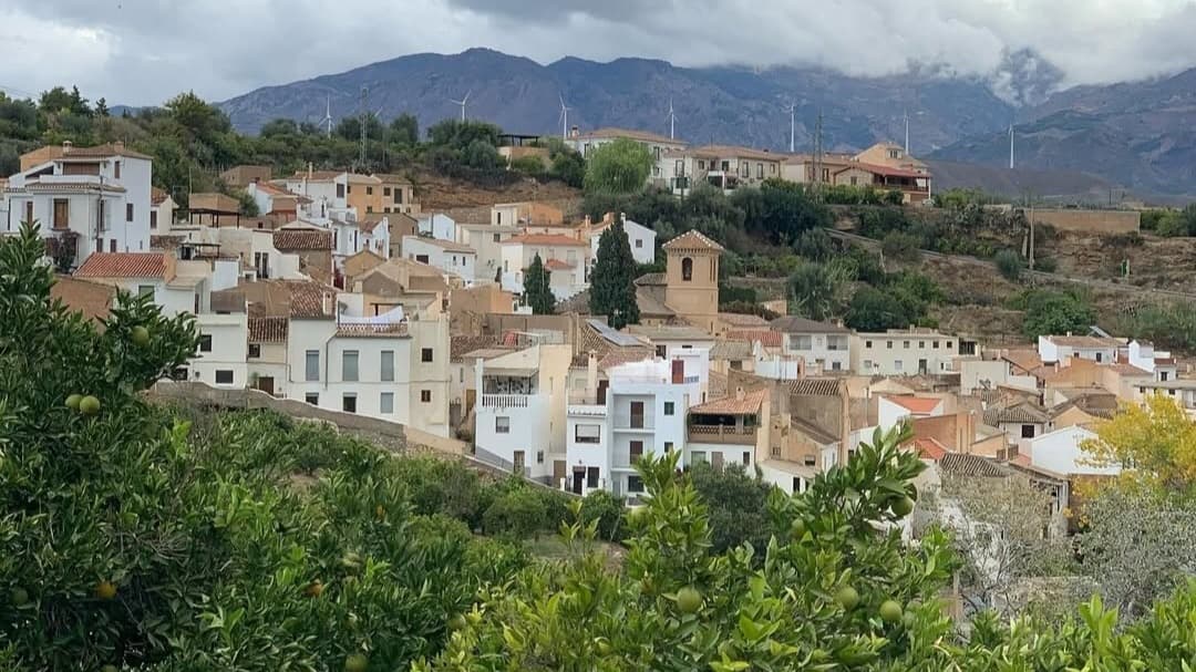
View of AlbuñuelasMiguel Perdiguero · CC0

Albuñuelas

Village

Albuñuelas is a village at the head of the Lecrin Valley, Granada, Spain. It is made up of three neighbourhoods (barrios): Alto, Bajo and Fernán Núñez (locally called La Loma). It is situated on the European route Nº 4 (Spain to Crete).

Text from Wikipedia (CC BY-SA)

Village information

Coat of arms of Albuñuelas
Province
Granada
Autonomous community
Andalucía
Population (INE 2025)
794
Altitude
728 m
Area (IGN)
139 km²
Postcode
18659
View on the map
  • Overview
  • See and do
  • Events
  • Stay
  • Eat
  • Live here
  • Opportunities
  • Practical info
  • Gallery

Keep exploring

More villages near Albuñuelas

Surprise me
Luispihormiguero · CC0El ValleGranada · 4.3 km away
Centro-guadalinfo · CC BY-SA 4.0El PinarGranada · 7.1 km away
J.M.Martín León · CC BY-SA 4.0LecrínGranada · 7.5 km away
Fran P. · CC BY-SA 4.0VillamenaGranada · 7.9 km away

Where to sleep in Albuñuelas

34 registered places to stay

See places to stay
PreviousOverviewBack to homeNextEvents

What to see

12 places to explore Albuñuelas at your own pace. Each number matches its point on the map.

Ask Poblete for a route

Tell me how much time you have and what you like, and I'll put the places in Albuñuelas in order so you don't go back and forth.

How much time do you have?
How are you getting around?
What do you like? (you can pick several)

Only with places listed for Albuñuelas.

My route around Albuñuelas

Tap “+ Add to my route” on the places you want to see. We'll split what you can do on foot from what's better by car.

Places you can add

  1. 1

    1.

    La Torre del Tío Bayo (o Vayo) es una construcción defensiva de época nazarí situada en el casco urbano de la localidad española de Albuñuelas, cabeza del municipio de igual nombre, en la provincia de Granada, Comunidad autónoma de Andalucía (España).

    Torre fortificadaBien de interés cultural

    Torre del Tío Bayo
    AlfonsoERomero · CC BY-SA 4.0
  2. 2

    2.

    Torre fortificadaBien de interés cultural

  3. 3

    3.

    Iglesia

  4. 4

    4.

    Mirador

  5. 5

    5.

    Cumbre

  6. 6

    6.

    Ruinas

  7. 7

    7.

    Ruinas

  8. 8

    8.

    Cumbre

  9. 9

    9.

    Cumbre

  10. 10

    10.

    Cumbre

  11. 11

    11.

    Cumbre

  12. 12

    12.

    Cumbre

Monuments from Wikidata; summaries from Wikipedia (CC BY-SA) and photos from Wikimedia Commons, credited to their authors.

What to do

7 plans to experience Albuñuelas on the move, not just passing through.

Hiking

3 activities

Hiking: GR 7 · Andalucía - South Route (Provincia de Granada)

Hiking: PR-A 308 · Camino de los Arrieros

Hiking: PR-A 309 · El Pozuelo

More routes on WikilocHiking routes on Google Maps

Natural areas

1 activity

Parque Natural Sierra de Tejeda, Almijara y Alhama

Getting there

Wineries

1 activity

Bodega Bernardo Harapa

Getting there

Bike

2 activities

MTB: La Mamut - Padúl

MTB: Transandalus

Cycling routes on Google Maps

Places and plans from OpenStreetMap (ODbL): what is mapped within the municipal boundary, by name. If something is missing, it can be added there and will appear here in the next update.

In and around Albuñuelas

What there really is in the village and around it, with distances. If an activity isn't on this list, we haven't found it nearby.

  • WineriesBodega Bernardo Harapa · in the village · 4 within 15 kmGetting there
  • Reservoirs and lakesEmbalse de Béznar · 4.9 km away, in Valle (El) · 2 within 15 kmGetting there
  • Via ferratasVia Ferrata Tajo de las Vinas · 11 km away, in LentegíGetting there
  • Spas and hot springsBalneario de Lanjarón · 12.5 km away, in LanjarónGetting there
  • SurfingEscuela de Windsurf Wingfoil Granada · 14.7 km away, in ÓrgivaGetting there
  • GolfSanta Clara Golf Granada · 16.7 km away, in OturaGetting there
  • ClimbingUnnamed on the map · 17 km away, in Salobreña · 2 within 20 kmGetting there
  • Water parksAquatropic · 22 km away, in AlmuñécarGetting there
  • Skiing and snowEstación de Esquí y Montaña de Sierra Nevada · 27 km away, in MonachilGetting there