FavouritesSign inCreate accountAdd my village

The guide to Spain's villages, one municipality at a time.

Your village is waiting for you.

@8000pueblos

Explore

  • Villages
  • Create my route
  • Experiences

Practical guide

  • Guides
  • About us
  • How it works
  • Village comparison
  • Map of Spain
  • Opportunities
  • Living in a village

Join us

  • Create your account
  • For town councils
  • For professionals
  • Contact

© 2026 8000pueblos.com

Some links are affiliate links: if you book, we receive a commission at no cost to you.

SupportPrivacyTermsCookiesLegal notice
en
  • Español
  • English
  • Français
  • Português
  • Italiano
Sign inCreate account
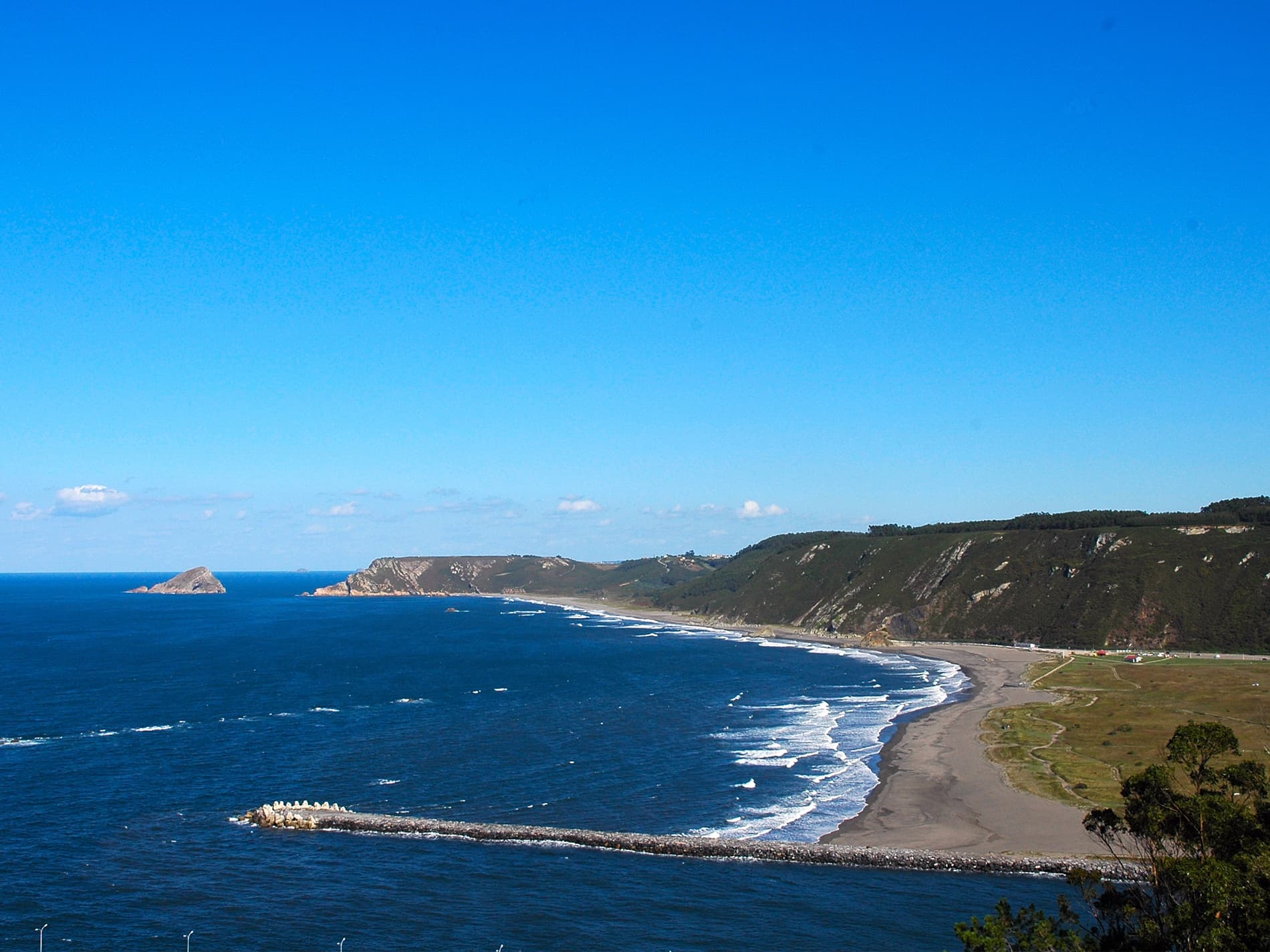
View of Soto del BarcoRMNORIEGABMS · CC BY-SA 2.5

Soto del Barco

Coastal village

Soto del Barco (Asturian: Sotu'l Barcu) is a small, coastal municipality in the Autonomous Community of the Principality of Asturias, Spain. It is located on the banks of the mouth of the Nalón and along the Cantabrian coast. As of 2023, the municipality is home to 3,818 people who reside in five parishes: Soto del Barco, L'Arena, Ranón, Riberas, and La Corrada.

Read moreRead less

After the Roman occupation of Iberia, a fort, which had been constructed in the area in order to defend the mouth of the Nalón, was either restored or reconstructed by Alfonso III; this fort is still standing and is known as the Castillo de San Martín. Until 1836, Soto del Barco fell under the municipality of Pravia; it became independent on 29 December. Its population reached its peak at over 6,000 in the 1960s; due to the weakening of the local fishing and canning industries, the population has fallen markedly since that decade. The service and tourism industries are now the largest in the municipality.

Text from Wikipedia (CC BY-SA)

Village information

Coat of arms of Soto del Barco
Province
Asturias
Population (INE 2025)
3,801
Altitude
68 m
Area (IGN)
32.8 km²
Postcode
33458
View on the map
  • Overview
  • See and do
  • Events
  • Stay
  • Eat
  • Live here
  • Opportunities
  • Practical info
  • Gallery

What to see

  1. 1Centro de Interpretación Puerta del Mar
  2. 2Casa Corujedo
  3. 3Casa de "Gregorio Paz"
  4. 4Casa de "Marcelina y Pancho"
  5. 5Casa de "Pacho Cuevas"
  6. 6Casa de Ana Fierro
Data from OpenStreetMapSee more

What to do

  1. 1Hiking: Camino del Norte (Asturias)
  2. 2Playa de los Quebrantos
  3. 3MTB: Mtb Camino del Norte (Asturias)
  4. 4Cycling route: Camino de Santiago (tramo Camino del Norte)
  5. 5Club Deportivo Remeros del Nalón
  6. 6Hiking: Senda Costera de Arnao a San Juan de la Arena
Data from OpenStreetMapSee more

Photo gallery

See all photos
  • Vanbasten 23 · CC BY-SA 3.0
  • Ivan Gonzalez · CC BY-SA 3.0
  • José Antonio Gil Martínez from Vigo, Spain · CC BY 2.0
  • Wikimedia Commons · Public domain
  • Wikimedia Commons · Public domain
  • Denis Soria · CC BY-SA 3.0
  • Illustrative photo · Unsplash

    Accommodation

    No places to stay listed yet

    See places to stay
  • 21 restaurantsIllustrative photo · David Adam Kess · CC BY-SA 4.0

    Eat

    21 restaurants in Soto del Barco

    See where to eat
  • 6 experiencesIllustrative photo · Mario Freedom Sánche… · CC BY 3.0

    Experiences

    6 experiences in Soto del Barco

    See experiences

Useful information

Everything you need for your visit or your day-to-day

Tap a row to see it on the map and how far away it is.

Town council

    • Phone: 985 58 80 13
    • Official website: www.sotodelbarco.com
    • Email: info@sotodelbarco.com

Services and transport

Travelling with your pet

Parks, beaches and places to stay that OpenStreetMap marks as dog-friendly. Many places allow dogs without it being marked: ask when you book.

Education, sport and elderly care

Connectivity

  • Fibre broadband· of homes70 %
  • 4G mobile coverage· of homes100 %
  • 5G coverage· of homes100 %

No data on: tourist office, ATMs, motorhomes, street market, nursery school, secondary school, pool.

Data from OpenStreetMap (ODbL), extract from October 2026: we count what is mapped within the municipal boundary. "No data" means OpenStreetMap doesn't have it, not that it doesn't exist. Completed with Overture Maps (CDLA-Permissive-2.0): the pharmacies, health centres, petrol stations, banks, cash machines, food shops and schools that OpenStreetMap was missing. Town hall contact details: General Database of Local Entities (Spanish Ministry of Finance); tourist offices: each region's open registry, where it publishes one. Connectivity: Spanish Ministry for Digital Transformation, % of homes covered in June 2025.

Soto del Barco Town Hall

Municipal information, services, procedures and grants.

Go to municipal information

Keep exploring

More villages near Soto del Barco

Surprise me
J L Maral · CC BY-SA 2.0Muros de NalónAsturias · 2.7 km away
Crisjerez · CC BY-SA 4.0PraviaAsturias · 5.9 km away
Vilanchelo · CC BY-SA 4.0CudilleroAsturias · 6.8 km away
Carmenmoran · CC BY 4.0CastrillónAsturias · 8.4 km away
Back to homeNextSee and do