FavouritesSign inCreate accountAdd my village

The guide to Spain's villages, one municipality at a time.

Your village is waiting for you.

@8000pueblos

Explore

  • Villages
  • Create my route
  • Experiences

Practical guide

  • Guides
  • About us
  • How it works
  • Village comparison
  • Map of Spain
  • Opportunities
  • Living in a village

Join us

  • Create your account
  • For town councils
  • For professionals
  • Contact

© 2026 8000pueblos.com

Some links are affiliate links: if you book, we receive a commission at no cost to you.

SupportPrivacyTermsCookiesLegal notice
en
  • Español
  • English
  • Français
  • Português
  • Italiano
Sign inCreate account
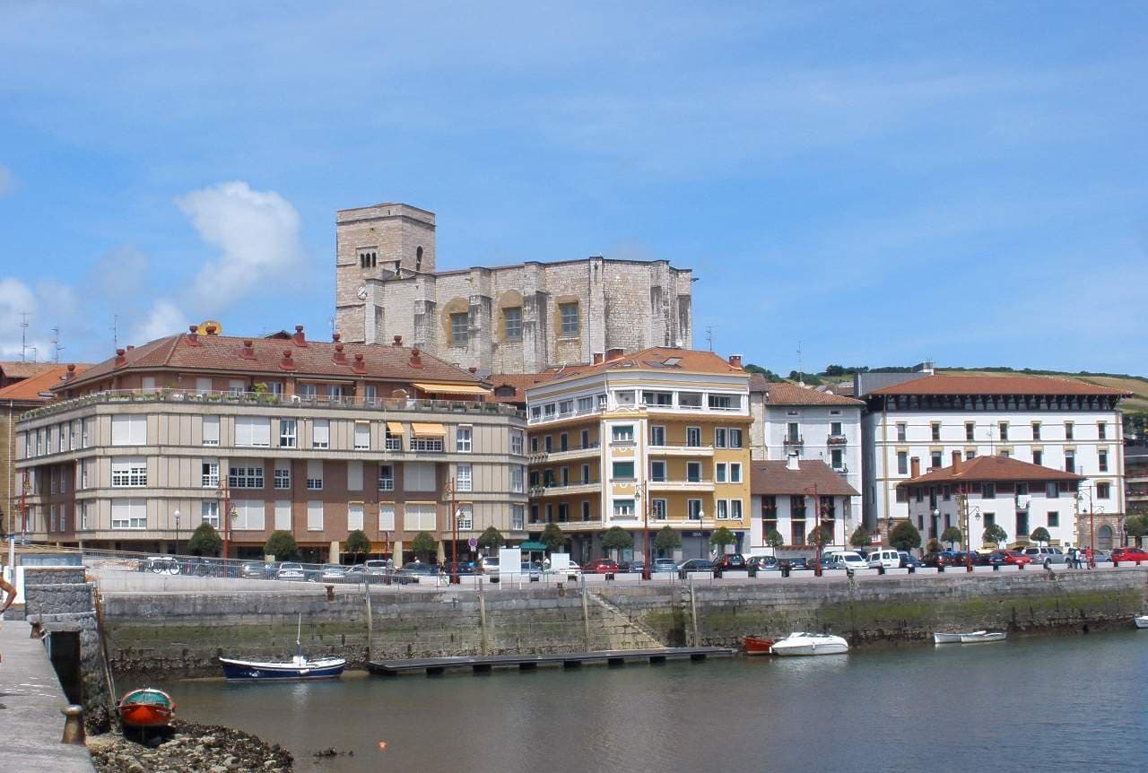
View of ZumaiaZarateman · CC0

Zumaia

Coastal town

Zumaia is a small town in the north of Spain in the Basque Country.

Read moreRead less

The town has two beaches (Itzurun and Santiago), which are of interest to geologists because they are situated among the longest set of continuous rock strata in the world. These formations are termed flysch and they date from the mid-cretaceous period to the present, a time period of over 100 million years. The K–T boundary is present at the Itzurun beach, and fossils can be found, notably of ammonites. The strata stretches along a distance of about 8 km, between the beaches of Deba and Getaria, with Zumaia lying in the middle.

The town is also the home-turned-museum of the painter Ignacio Zuloaga. Exhibits include works by El Greco, Rivera, Zurbarán and Goya. Across the street there is a museum of craft and hand-crafted products of Laia. Within the city centre, the Basque-style Gothic church of San Pedro can be found. It has a temple with a magnificent reredos by Juan de Antxieta, the only work by this Basque sculptor found in Gipuzkoa.

Zumaia is located at the point where the Urola and Narrondo rivers come together. The origins of the town can be traced by its ancient monastery. In the Middle Ages, the people who lived in the Sehatz valley having to endure the continuous attacks of pirates and pillagers, fortified the city. The church today retains the relic of its defensive appearance.

Text from Wikipedia (CC BY-SA)

Village information

Coat of arms of Zumaia
Province
Gipuzkoa
Autonomous community
País Vasco
Population (INE 2025)
10,160
Altitude
8 m
Area (IGN)
10.6 km²
District
Urola Costa
Postcode
20750
View on the map
  • Overview
  • See and do
  • Events
  • Stay
  • Eat
  • Live here
  • Opportunities
  • Practical info
  • Gallery

What to see

  1. 1Iglesia de San Pedro
  2. 2Torre Ubillos
  3. 3Faro de Zumaya
  4. 4Casa-museo de Zuloaga
  5. 5Casa de Aguirre
  6. 6Ermita de Santiago
Data from WikidataSee more

What to do

  1. 1Hiking: Camino del Norte (Euskal Herria)
  2. 2Hiking: GR 121 · E04 Talaia ibilbidea: Orio - Zumaia
  3. 3Paisaje Natural Protegido del tramo litoral Deba-Zumaia
  4. 4Playa Santiago hondartza
  5. 5Hiking: Geoparkeko Bira - Deba-Zumaia
  6. 6Cycling route: Donostia - Mutriku
Data from OpenStreetMapSee more

Photo gallery

See all photos
  • Gartxoak · CC BY-SA 4.0
  • Basustako · CC BY 4.0
  • Rodrigo Gómez Sanz from Madrid, España · CC BY 2.0
  • Gartxoak · CC BY-SA 4.0
  • ElsaBornFree · CC BY-SA 4.0
  • 10 places to stayIllustrative photo · Unsplash

    Accommodation

    10 places to stay in Zumaia

    See places to stay
  • 29 restaurantsIllustrative photo · Basotxerri · CC BY-SA 4.0

    Eat

    29 restaurants in Zumaia

    See where to eat
  • 8 experiencesIllustrative photo · Mario Freedom Sánche… · CC BY 3.0

    Experiences

    8 experiences in Zumaia

    See experiences

Useful information

Everything you need for your visit or your day-to-day

Tap a row to see it on the map and how far away it is.

Town council

    • Phone: 943 86 50 25
    • Official website: zumaia.eus
    • Phone: +34 943 143 396
    • Website: zumaia.eus
    • Email: turismoa@zumaia.eus

Services and transport

Travelling with your pet

  • Camping Zumaia· Campsite

    Phone: +34 943 86 04 75Website: www.campingzumaia.com

Parks, beaches and places to stay that OpenStreetMap marks as dog-friendly. Many places allow dogs without it being marked: ask when you book.

Education, sport and elderly care

Connectivity

  • Fibre broadband· of homes100 %
  • 4G mobile coverage· of homes100 %
  • 5G coverage· of homes100 %

No data on: EV chargers, motorhomes, street market, pool.

Data from OpenStreetMap (ODbL), extract from October 2026: we count what is mapped within the municipal boundary. "No data" means OpenStreetMap doesn't have it, not that it doesn't exist. Completed with Overture Maps (CDLA-Permissive-2.0): the pharmacies, health centres, petrol stations, banks, cash machines, food shops and schools that OpenStreetMap was missing. Town hall contact details: General Database of Local Entities (Spanish Ministry of Finance); tourist offices: each region's open registry, where it publishes one. Connectivity: Spanish Ministry for Digital Transformation, % of homes covered in June 2025.

Zumaia Town Hall

Municipal information, services, procedures and grants.

Go to municipal information

Keep exploring

More villages near Zumaia

Surprise me
Arseniog · CC BY-SA 4.0GetariaGipuzkoa · 4.3 km away
Asier Sarasua Aranberri · CC BY-SA 2.0AizarnazabalGipuzkoa · 4.9 km away
Txo · Public domainZestoaGipuzkoa · 6.4 km away
Millars · CC BY-SA 4.0ZarautzGipuzkoa · 7.2 km away

Where to sleep in Zumaia

10 registered places to stay

See places to stay
Back to homeNextSee and do